Ok. It takes longer to write these things than we thought, so, you know we didn't write them. And now we are in Wellington. Crap. Oh well. I will write a blog of the highlights of our trip from Hamilton onwards...
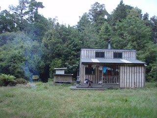
Right well, we left off from our rest day at McLaren Falls which was epic so I will start from the next day, which, incidentally was a great significance. The idea of staying in a DoC hut had invaded our heads and we consequently decided that it would just be a swell idea to walk from Hamilton to the top of Mt Pirongia. Undaunted by the maps we cruised down the roads without so much as a hint of fatigue... that is until 16:00. We had just walked 19.5 miles and up Couchran road (steep and unrelenting) in the midday heat of the clearest day yet. Blown away by the views we had our late lunch and recuperated in the shade of some pine and kawakawa trees. With our lunch finished we started another days walk - the DoC signs suggested a 7 hour walk to the top (a typical length for one of our days!). It started steep and by the time we had lugged our full packs to the Trig point our lungs were burning and we were almost sick due to shear exhaustion. Collapsing onto the bench and breathing allowed us the time to think about where we are! Near half way to the top of our first real mountain in the middle of New Zealand in summer. Man our lives aren't all that bad! Its getting hard now to even think about how hard we worked to get to here. We must be getting fit now, we cut DoC's timing in half! a long ways yet though. We climbed and scrambled up steep volcanic faces with bolted chains to steady ourselves with our fully packed Eagle Creek 65ltr Truist Backpacks and up and down ridges over and over again, always going up. The final sign - 30 mins to summit, I was pumped, so much adrenaline, started sprint walking... 6 minutes! But what a view! I feel for anyone who does this in the cloud... we could even see Ruhapehu! and Hamilton in the far distance!


After leaving Pahautea Doc Hut, it was a very muddy and slippery descent of Pirongia and we had a few falls here and there; but nothing serious. It was a hot and sticky day, so we all became irritable while walking along metal road. On the other hand the views of the Kawhia coast were still as amazing as the previous night. We took shelter underneath a bridge and had some lunch. This lunch session then became an eal man hunt, as we spotted our first eal and were determined to catch one. Unofrtunately our fishing methods were unsuccussful. A navagational mistake and a swift solution brought us back on track in the bush; but things didn't get any better, DM bashed his nose with his trekking pole and Landey fell face first into the wet marsh.

 The next day we saw a rare sight of two boxing hares. Our fortune was about to change for the worse as the lovely Te Araroa markers disapeared into head height gorse. After a good hour of battling the menace brought over form England, we headed back to the top of the Valley. Taking a bearing with the compus we head along our own path. The Tasty Trek trail. We ended up on Queens land and then a friendly farmer told us how to get out to the road. DM's bag had broken so there was work to be done once in Waitomo, Juno Hall BBH.
From Waitomo we walked along the road to Mangaokewa reserve, which was a really nice camp site and this was the location of the first of tasty trek's favourite dinner. While walking Anders and Landey got sprayed witha smelly liquid as a truck full of cows drove by. I can honestly say no one i know of has ever been pissed on by a cow moving at 80km/h! The next day we walked along the Mangaokewa track which is described to be very pleasant with a wide path. Well its definitely not wide and in fact it was very challenging becasue the track was over-grown with gorse on the up hil and bramble on the down hill. It was a scratchy experiance. We then got a bit confused and ended up 3 miles of the track; however if this didn't happen a poor sheep would have died. It was fate for tasty trek and sir sheep to meet. Also it was hilarious watching Anders and Landey struggle pulling this sheep out of a bog! Back on track we pitch tent in a field next to a river. Eager to catch an eel for dinner we went about again fishing. Success! Just as we were all about to pack our gear away, the fishing line started to violently move, and tasty trek got their first very tasty eel.

 The next day was suprisingly quick for the huge distance we walked (24 miles). It helps listening to music when doing long raod sections. We got to Pureora DOC Campsite in good time for us the nap and start a nice fire and chill. The day after to the summit of Pureoa was amazing as the views were incredible and gave us a 360 view of Pirongia to the North and Lake Taupo to the South. The walk through this forest was one of our favourite as it wasn't savage up and down but a constant horizontal all the way to Bogg Inn hut. This hut rocked with character and we had a competition to see who could chop the smallest piece of wood. Walking in the bush is very different to walking on roads. As obvious as this remark seems, we were suprised to see how slow going it was in the bush per mile. While pondering the exact amount we walk an hour in the bush a dog jumped out with is hunter owner and scared the crap out of us! He told us that the Pureoa forest was the most heavily poisoned forest in NZ. At Waihaha hut we met some biologists who were collecting ferns to measure the impact of deer on the forest. They gave us loads of their food the next day as we left to the next hut. Well turned out there was no hut so we ended up camping on the side of the road. The walk to Taumaranui Holiday Park Campsite was along road the whole way, so instead of listening to music like we normally do we tried to tell stories of movies we had seen or books we had read in the past. It is a good way to keep the mind occupied. Once in Taumaranui the information ladies helped us out for a place to stay even organised a ride to pick us up! Getting to Taumaranui was a big step in our journey so we had a rest day, insidently it wasn't in Taumaranui but in Ohakune because it had shuttle buses to the Tongariro Crossing.
The Tongariro Crossing is expensive to get to by shuttle but the walk is definitely worth it! We didn't find it that challenging to walk, in fact we even ended up running at the lowere sections of the trail. Lots of fun as we had to skip around people and jump down stairs. Although i have to admit i thought i was going to chunda when we got to the bottom. Before finishing the crossing though we had to climb Mt Ngauruhoe AKA Mt Doom! This was a difficult but worth while climb up scree and loose rock. Unfortunately we didn't get to see much of a view at the top as the clouds had come in; but we were made famous on Mt Doom. An Austian couple said they had heard of us from the French woman we met earlier on 90 mile beach! Awesome! When everyone had gone we took the liberty to strip off under cloud cover and pose for a photo.... Common, how many people can say they have stood naked ontop of Mt Doom? When we got back to we were running about trying to organise the next epic part of our trip down the Whanganui river.

 Lots happened on this river, so i'm going to summarise all the best parts ... theres ALOT! We set off from Taumaranui down the river with Anders and Landey in the canoe and DM in the kayak. It was a beautiful day and the river level was apparently low so the rapids were more rapid. It was cool being on the river, because we had talked about it so much when walking and now we were finally on it. We stopped at Poukaria Campsite. It was great to stuff our selves on the river because the barrels in th canoe allowed us to take way more food! It started to rain the next day and we didn't want to leave the campsite because we were all nice and warm. After putting on our wet gear again we paddled to warm the muscles. It was great on the river now as it was moving really fast and we didn't have to paddle that hard. After manouvering through some rapids we heard this roar and to our dis-belief, there was a waterfall gushing out of the wall so massive it almost came across the river, which was narrow at this point. Landey and DM were in the canoe and tried to power there way through the side current the waterfall had created in the river. Well it didn't work well and we ended up being slammed against the side of the gorge and nearly cap-sized. After this adrenaline pumping ordeal we thought that we might need to get off the river soon. Once at Whakahoro the river was raging and we made a tactical stop at Lacy's landing which is were we met a man called Dan Steele who was rescuing his speed boat before it too disapeared. We hauled our gear out of the river and pulled it up to the tree line and tied the canoe and kayak up. Dan gave us a lift to the DOC hut next to his. Dan is a farmer but conservationist at heart, taking special care of the Blue Duck. He let us shower at the Blue Duck Lodge and we settled down dry talking to the people in the lodge. We decided it would be best if we had a rest day in at the lodge and wait for the river to go down. Two siblings, Andy and Cathy also had the same idea and had a safety day (we were staying with them in the DOC hut). We loved the Blue Duck lodge and all the people there, especially a man called Gary who took us hunting with the John the chef. They got three goats and kindly gave us one. Hell yeah! Back on the river after the rest day was pleasant enough when suddenly Andy from the DOC hut waved us down from the side of the river bank. As it happened Andy got sucked in by a very large Whirlpool which turned out to the bain of the river. We spent the night on the river bank with Andy and Cathy. The next day we beat the whirlpool and headed down river to the next hut. Unfortunately there was no warden so we left a message on the board with Andy's and Cathy's 10 digit gps location on it. After this it was a very pleasant rest of the day, as we pulled up to our next stop 'The Bridge to Knowhere'. What a place! It has an eery feel to it as this large cncrete structure connects two sub-tropical rain forests. The next stop along the river was, Tieke Kainga Marae. A Maori woman called Lesleigh took care of the place and she taught us loads of craft using a local plant called Flax. Lesleigh also let us help our selves to all the food the Marae had. Apparently 80 people were stranded there when the river was in 10 meter flood. The next day we canoed and kayaked to Pipiriki. It was more or less uneventlyful, except the strong wind made it really difficult to paddle. In Pipiriki we met a really interesting old man who told us about Maori culture. The following sections of the river were easy going except for the wind as it gradually increased the further down river we got. Infact Anders Fell in the river due to the wind!. The rest of the journey from Downes hut (Awsome hut) to Whanganui was less impressive as we came out of the national park and the lanscape turned into farmland. FINALLY WHANGANUI!

 We took a rest day in Whanganui with the woman Cathy who we met on the river. Tasty Trek on Classic Hits with Phil Lemon was our next new experience. Just trying to spread the work to raise the donations. Cathy picked us up and drove us down the to begining of our next walk. We walked to Fusilier Wreck along the coast line which is really cool, covered in large dead peices of wood and even whole trees. oh! and afew dead cows along the way as well. With the mass amount of dead wood we decided to build a shelter and sleep under the stars. A decision we came to regret as we woke up with sand everywhere! Walking along the west coast meant we couldn't go swimming as it was too rough, not to mention there would probably be loads of drift wood about. However we did get wet when we had to cross two major rivers. Re-organising our gear to ensure it is water tight, we pack floated our gear across while we swam next to them. The second river crossing was savage and longer than we thought. The next couple of walking sections was pretty boring from Himatangi Beach to Levin to Otaki, to Otaki forks, all along the roads. From Otaki forks however we tramped into the Tararua Ranges along Judd Ridge to Field hut. The weather was rainy, and cold but we had to go on. The whole two days was pretty much all up in bush at first but as we got to 1400 meters the bush disapeared and we were just walking through low lying bush. The weather took a turn for the worse when we were on top of Mt Hector (1520m) and Anders gor blown off the ridge. We all hit exhaustion and decided to head back down to Otaki Forks the next day. I have to say though, it was a really fun experience. From Otaki Forks we walked half way and then hitched to Otaki and then hitched the next day to Tawa. The hitching is justified as we walked the miles on the ranges. From Tawa we walked to Wellington. Trelisick Park that took us to Wadestown, the park was awesome, although we are litteraly a stones throw from central Wellington the park was reminisient of some bush walks we had done right out in the countryside. It was nice. On emerging from the park we were now following the Northern Walkway as well as the Te Araroa trail, for the next bit we had to climb an insanely steep road hat took us upto Tinakori Hill, from up here we had some really great views of central Wellington. The walk down the hill toward the city took us though some nice forest bits, we met many cyclist along the way. The trail then took us through the botanical gardens and it was only a cable cart away to the city! HALF WAY!
I wouldn't change a single thing about the the trip up until this point. Its been AWESOME! .... peanut butter butter
Right well, we left off from our rest day at McLaren Falls which was epic so I will start from the next day, which, incidentally was a great significance. The idea of staying in a DoC hut had invaded our heads and we consequently decided that it would just be a swell idea to walk from Hamilton to the top of Mt Pirongia. Undaunted by the maps we cruised down the roads without so much as a hint of fatigue... that is until 16:00. We had just walked 19.5 miles and up Couchran road (steep and unrelenting) in the midday heat of the clearest day yet. Blown away by the views we had our late lunch and recuperated in the shade of some pine and kawakawa trees. With our lunch finished we started another days walk - the DoC signs suggested a 7 hour walk to the top (a typical length for one of our days!). It started steep and by the time we had lugged our full packs to the Trig point our lungs were burning and we were almost sick due to shear exhaustion. Collapsing onto the bench and breathing allowed us the time to think about where we are! Near half way to the top of our first real mountain in the middle of New Zealand in summer. Man our lives aren't all that bad! Its getting hard now to even think about how hard we worked to get to here. We must be getting fit now, we cut DoC's timing in half! a long ways yet though. We climbed and scrambled up steep volcanic faces with bolted chains to steady ourselves with our fully packed Eagle Creek 65ltr Truist Backpacks and up and down ridges over and over again, always going up. The final sign - 30 mins to summit, I was pumped, so much adrenaline, started sprint walking... 6 minutes! But what a view! I feel for anyone who does this in the cloud... we could even see Ruhapehu! and Hamilton in the far distance!


After leaving Pahautea Doc Hut, it was a very muddy and slippery descent of Pirongia and we had a few falls here and there; but nothing serious. It was a hot and sticky day, so we all became irritable while walking along metal road. On the other hand the views of the Kawhia coast were still as amazing as the previous night. We took shelter underneath a bridge and had some lunch. This lunch session then became an eal man hunt, as we spotted our first eal and were determined to catch one. Unofrtunately our fishing methods were unsuccussful. A navagational mistake and a swift solution brought us back on track in the bush; but things didn't get any better, DM bashed his nose with his trekking pole and Landey fell face first into the wet marsh.


From Waitomo we walked along the road to Mangaokewa reserve, which was a really nice camp site and this was the location of the first of tasty trek's favourite dinner. While walking Anders and Landey got sprayed witha smelly liquid as a truck full of cows drove by. I can honestly say no one i know of has ever been pissed on by a cow moving at 80km/h! The next day we walked along the Mangaokewa track which is described to be very pleasant with a wide path. Well its definitely not wide and in fact it was very challenging becasue the track was over-grown with gorse on the up hil and bramble on the down hill. It was a scratchy experiance. We then got a bit confused and ended up 3 miles of the track; however if this didn't happen a poor sheep would have died. It was fate for tasty trek and sir sheep to meet. Also it was hilarious watching Anders and Landey struggle pulling this sheep out of a bog! Back on track we pitch tent in a field next to a river. Eager to catch an eel for dinner we went about again fishing. Success! Just as we were all about to pack our gear away, the fishing line started to violently move, and tasty trek got their first very tasty eel.


The Tongariro Crossing is expensive to get to by shuttle but the walk is definitely worth it! We didn't find it that challenging to walk, in fact we even ended up running at the lowere sections of the trail. Lots of fun as we had to skip around people and jump down stairs. Although i have to admit i thought i was going to chunda when we got to the bottom. Before finishing the crossing though we had to climb Mt Ngauruhoe AKA Mt Doom! This was a difficult but worth while climb up scree and loose rock. Unfortunately we didn't get to see much of a view at the top as the clouds had come in; but we were made famous on Mt Doom. An Austian couple said they had heard of us from the French woman we met earlier on 90 mile beach! Awesome! When everyone had gone we took the liberty to strip off under cloud cover and pose for a photo.... Common, how many people can say they have stood naked ontop of Mt Doom? When we got back to we were running about trying to organise the next epic part of our trip down the Whanganui river.


 |  |  |
I wouldn't change a single thing about the the trip up until this point. Its been AWESOME! .... peanut butter butter

